





By Lucy Malamud-Roam
Come now, I want to sit with you by the river. I want you to feel the cool, wet sand on the pads of your feet, to inhale the earthy smell of just-wetted leaves, and hear the rush of water and the cries of shorebirds as they pick through the soft mud looking for bugs. The sun just rose, and its light catches on the water’s surface in little silver ribbons. All around us green-blue dragonflies patrol, snatching midges from the air. Their glassy wings, nearly the width of my hand, glitter gold in the morning light.
Watch them with me, won’t you? We could sit here all day, in the shade of the cottonwoods. Pick a pair to lean against and feel their furrowed bark against our backs. Pale brown like milky coffee, set ablaze by golden leaves. We can rest our legs along their thick roots, watch them sink deep into the floodplain and drink from the sodden earth. We can pretend we’re roots, sink our toes deep into the damp sand and let the water swallow our ankles and send sediment dancing. Or better yet, let’s be the leaves. Let’s drift out toward the center of the river until the current catches us and carries us away.
Let’s stay like this for a moment. I can keep feeding you pretty half-truths to improve the picture. We can pretend this is still what the Rio Grande looks like in Albuquerque: a bright, broad river that you can be carried away on, rather than one increasingly broken into scattered pools and miles of bare sand, cottonwoods shedding limbs along with leaves as the water retreats. We can pretend there is always water around my ankles this time of year, that the drought has ended and none has been diverted upstream. That beneath the wet sand, rushing water, dragonflies, and shorebirds is not the same bare riverbed that was here yesterday and will return when the rain recedes. That the mountain snowpack has replenished, and the river can still make its long journey south from the snowfields of Colorado’s San Juan Mountains to the Gulf of Mexico. Let me stay here, please, just a little longer, and pretend this abundance is ordinary.
And then I will go home. I will leave the river, brush the sand from my feet, turn on the faucet, and — as if I were still ankle-deep in my riparian reverie — watch water pour out. Abundant again.
If you couldn’t already tell, I revere nature. I studied ecology and biology in college, and much of my work since graduating has been focused on habitat restoration. I’ve spent my career breaking ecosystems into their component parts and studying each one: plants, animals, fungi, soils, rocks, water. After allowing myself to grow enraptured by each glittering piece, I fit the mosaic back together to understand how the entire landscape functions so I may endeavor to steward it.
Over the years, I have worked with the most brilliant people: stewards who have devoted their lives to healing hurt landscapes, retirees who plant trees whose shade they may never sit beneath, and children whose excitement makes even small signs of recovery feel miraculous. When your work requires you to look closely at what humans have done to the natural world, it would be easy to conclude that we are the problem. To be sure, many environmentalists do. But I have spent too much time witnessing people care deeply for damaged places to believe that destruction is the whole of our relationship with the world. My time as a restoration ecologist has led me to believe that humans are not an inherent burden on the planet, but an integral part of it — necessary stewards whose presence can serve as good medicine for the Earth.
It is that profound faith in humanity that has brought me to the University of New Mexico to pursue graduate study in geography. Contrary to popular belief, geography is not merely the study of maps or a mispronunciation of “geology.” Geography is the study of place: why things happen where they do, how landscapes shape the lives within them, and how those lives reshape the landscape in return, with particular attention to the role of people. Restoration ecology helped me understand how a landscape functions; if people are to be responsible stewards of the Earth, we must understand not only plants, animals, soils, and water, but also the histories, laws, economies, infrastructure, and communities that determine what happens to them.
All those factors are present here in Albuquerque, along the Middle Rio Grande.
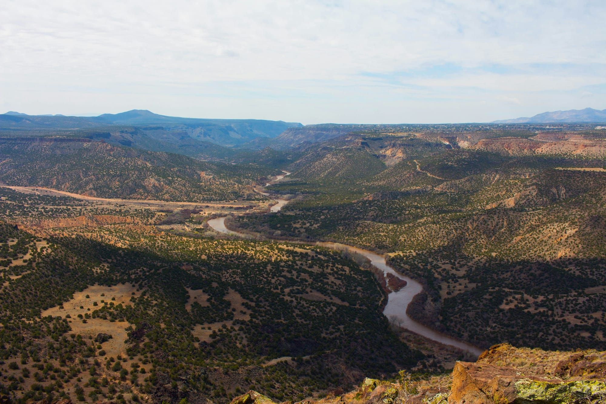
The Middle Rio Grande runs roughly 180 miles through central New Mexico, from Cochiti Dam south to Elephant Butte, the state’s largest reservoir. Albuquerque, the state’s principal urban center, and numerous smaller cities sit along its course. But cities are only one type of community tied to its water. Thousands of farms depend on the river, as do six Pueblo nations, and tens of thousands of acres of forest provide habitat for wildlife along its banks. Cities, farms, Indigenous communities, forests, fish, birds, and insects all rely on the same water moving through this valley.
In 2026, that shared water system is under extraordinary strain. New Mexico is in a severe drought. This winter brought one of the lowest mountain snowpacks on record and the earliest snowmelt ever recorded on the Rio Grande. Mountain snow acts as a kind of natural reservoir: It stores winter precipitation and releases it gradually as meltwater through the spring and summer. This winter brought unusually little snow to begin with, and much of what did fall melted too early to sustain the river through the hottest months. By late August, Elephant Butte had fallen to just 1.4 percent of capacity, and 112 miles of the Middle Rio Grande were completely dry.
Yet, bizarrely, nothing in my daily life has betrayed this scarcity. I still shower, wash my dishes, water my garden, boil water for tea. Every time I turn the tap, water still comes out.
That was no accident. The city of Albuquerque has spent decades building a water system capable of shielding its residents from years like this one. On April 24th, as river flows dwindled, the city’s Water Authority stopped drawing drinking water from the Rio Grande and fell back entirely on groundwater. The river could disappear and still our faucets would run. I find it dizzying, this extraordinary feat of engineering. Human ingenuity has masked a drought, just as last night’s storm has made a depleted river appear full. In both cases, what you can see and touch suggests abundance, even while the larger water system runs dry.
I considered this contradiction today, as I washed the river from my feet. It puzzled me. How have we built a way of life, here in Albuquerque, so insulated from the limits of our landscape — and can we remain insulated from them forever? Or, by engineering scarcity out of daily life, have we merely delayed the moment when those limits become impossible to ignore? As I do with every puzzle, I began examining its pieces one by one.
To understand my faucet, I first needed to understand the land beneath it. That story begins roughly 25 million years ago, when the crust beneath what would become Albuquerque began to stretch and pull apart slowly. One tectonic place sunk and created a deep depression — a basin — where the city of Albuquerque now sits. The one that lifted became the Sandia Mountains, which I now see to the east, glowing watermelon-pink in the setting sun.
The basin kept sinking as the crust continued to stretch. The mountains around it slowly wore away, and rain, wind, and streams carried their pieces downhill. Over millions of years, more than 14,000 feet of sediment accumulated beneath present-day Albuquerque. But all that sediment did not pack neatly together into solid rock. Between every grain of sand and piece of gravel remained tiny open spaces. Over time, water filled those spaces, turning the buried sediment into a vast underground reservoir.
Then came the river. About five million years ago, separate streams began joining across the Albuquerque Basin, gradually forming an ancestral Rio Grande. Over time, that river connected with headwaters in the high country of Colorado and carved the valley through which it still flows today.
By the time the modern communities of plants and animals along the Middle Rio Grande took shape, the basic architecture of life here was already in place: mountains rising above a deep basin, miles of water-bearing sediment below it, and a river moving south through the middle.
The water moving through that landscape followed a seasonal rhythm. Winter snow accumulated in the mountains of Colorado and northern New Mexico, then melted in spring and flowed through tributaries into the Rio Grande, swelling the river before summer heat drew it down again. Some of that water soaked through the floodplain into the aquifer beneath it, while groundwater seeped back toward the river in other places. Summer downpours could briefly send water rushing through a dry channel, but those short pulses could not replace the slow release of an entire winter’s snowpack.
The cottonwoods that line the Rio Grande offer perhaps the clearest example of how life evolved around the river’s rhythm. Each spring, snowmelt from the mountains raised the Rio Grande until water spilled beyond the channel and across its floodplain. Those floods cleared away existing vegetation and deposited fresh sand and silt. Then, in late spring and early summer, just as the floodwaters began to retreat, cottonwoods released clouds of tiny, windblown seeds. Those seeds landed on newly exposed, damp ground, then could germinate quickly and send roots downward after the receding water. Timing was everything: Without a flood there might be no suitable ground for a seed to claim, but if the water fell too quickly, a young tree could dry out before its roots reached lasting moisture. As the river shifted across the valley over decades, one flood might establish a new stand of cottonwoods while another carved a new channel or abandoned an old one, leaving behind a pond, marsh, or slow-moving backwater. The result was a constantly changing mosaic of sandbars, wetlands, willow thickets, young cottonwoods, and mature forest.
Animals arranged themselves within that mosaic. Each patch offered something different. Slow backwaters and side channels gave fish calmer water and places to feed or shelter away from the main current. Temporary pools created by floods and summer storms gave frogs and toads places to breed, while dragonflies and other aquatic insects developed in the shallow water and, in turn, became food for fish, birds, and bats. As cottonwoods matured, they added another layer of habitat: shade beneath their canopies, insects and leaf litter on the forest floor, and eventually hollows where woodpeckers, owls, and other birds could nest. Together these habitats formed the bosque — the ribbon of cottonwood-dominated riparian forest along the Rio Grande.
The bosque is not simply a forest that happened to grow beside the river. The river has repeatedly built and rebuilt it. Flooding and drying, erosion and deposition, channels forming and disappearing — these are the processes around which life along the Rio Grande has adapted.
Humans entered that same system more than 12,000 years ago. Early hunter-gatherer communities developed detailed knowledge of the river’s rhythms and, over thousands of years, cultivation became another part of life here. Maize appeared in the Middle Rio Grande archaeological record about 3,000 to 4,000 years ago, and by roughly 400 to 600 CE farming was supporting more settled communities. Farmers planted where floods, runoff, and summer rains left moisture behind and built terraces and small dams to slow water, trap soil, and sustain crops. By the 1300s, large Pueblo communities lined the river; Tiwa-speaking peoples settled throughout much of the Albuquerque valley, Keres-speaking communities sprang up elsewhere along the Middle Rio Grande, and Piro-speaking communities appeared farther south.
When Spanish colonists entered the Rio Grande Valley in 1598, they encountered Pueblo communities that had already been farming and diverting water for centuries. Colonization brought new crops, livestock, settlements, and systems for organizing land and water. Acequias — community-managed irrigation ditches — expanded across the valley, carrying river water by gravity to fields and tying its use to rules, labor, and shared infrastructure. Albuquerque, founded as a Spanish colonial villa in 1706, grew within this same irrigated landscape, its farms and households tied to the river through acequias just like other settlements along the valley. Across these communities, Pueblo and Hispano irrigation practices developed alongside and influenced one another.
For centuries, most efforts to control the Rio Grande remained local: a village diverted water into an acequia, irrigated nearby fields, and worked within whatever the river supplied that year. That began to change in the 19th century, as settlements and agriculture expanded the population’s demand for reliable water.
But the Rio Grande had always flowed unevenly and on its own schedule Each new settlement, new field, new acequira brought more reliance on a water system that wasn’t built to sustain it. Water still moved downhill, but more and more, it moved according to human design. .
New Mexico became a U.S. territory in 1848, and when the railroad reached Albuquerque in 1880, it connected the valley to rapidly expanding populations and distant markets. The population continued to grow, and along with it grew a demand for food, farmland, and water. Between 1880 and 1900, as New Mexico’s population rose from about 120,000 to 200,000, the number of farms in the territory more than doubled. By the 1890s, the system was already under strain. Drought and growing diversions upstream in Colorado were reducing the amount of Rio Grande water reaching the Middle Valley, even as demand continued to rise.
The river began responding to these changes as well. Upstream irrigation diverted more water from the Rio Grande, reducing the flow continuing downstream, while grazing, logging, and other land disturbance exposed soils that could wash into the river as sand and silt. That combined to mean more sediment entering the river and, at times, less water available to carry it away. Sand and silt accumulated on the riverbed, slowly raising the bottom of the channel. The higher riverbed prevented water from draining away from the surrounding floodplain, while irrigation ditches also leaked water into the ground. Groundwater crept closer to the surface beneath nearby farms, leaving some fields waterlogged. When that shallow groundwater evaporated in New Mexico’s dry air, it left dissolved salts behind, gradually making the soil less productive.
By the early twentieth century, farmers faced a strange combination: too little river water in some places, but too much in others. Solving the problem of getting more water onto the land had helped create a new problem: how to get water back off it.
So in 1925, communities along the Middle Rio Grande created the Middle Rio Grande Conservancy District to manage water across the valley as a single system. It built drains to dry waterlogged farmland, levees to contain floods, and diversion dams and canals to move river water more reliably to fields. Later, larger dams and reservoirs added another layer of control by holding back floods and storing water for release when it was needed. These projects worked: Farming became more reliable, floods became easier to manage, and water could increasingly be delivered on human schedules rather than the river’s.
But this kind of control accumulated its own consequences. Hold back the floods, and the river stops spilling across its floodplain, drying out wetlands and keeping fresh sediment from renewing the soils along its banks. Keep the river between levees and trap its sediment behind dams, and it loses much of its ability to shift course and build new habitats for fish, amphibians, birds, and insects. Cottonwoods suffer too. Unlike the redwood forests I’ve worked to restore in California, which gain structural complexity over centuries and support extraordinary biodiversity as they age, cottonwood forests are not meant to age in place. Redwood saplings are shade-tolerant; cottonwoods are not — they are not meant to grow in the shadow of their parents. Rather, they need open sunlight and the bare, wet sediment left behind by floods to establish a new generation. Without those disturbances, new stands become harder to establish and the bosque grows older without renewing itself. Bit by bit, the shifting mosaic the river had spent millennia creating became a narrower, more fixed landscape. The more predictable water became for people, the less freely the Rio Grande could behave like the river it had once been.
Now let’s zoom back in on Albuquerque, which was facing a different kind of water problem. By the 1870s, the city’s population was growing quickly, and with it grew the demand for dependable water that could not be met by the temperamental and in-demand river. So the city looked down, at the vast aquifer beneath the city — a reservoir that continues to receive new water even today. Wells could tap into it and pump water to the surface regardless of what the Rio Grande happened to be doing that day, that season, or that year. Albuquerque’s twentieth-century growth was built upon that reliability. Between 1940 and 1960 alone, the city’s population rose from roughly 30,000 to 200,000, and for most of the century nearly all of its drinking water came from groundwater.
But as Albuquerque grew throughout the twentieth century, the city pumped water from the aquifer faster than natural process could recharge it. By the 1990s, for every 100 gallons Albuquerque pumped, only about 54 gallons were being replenished by water seeping back underground; the remaining 46 represented a net loss from the aquifer’s stored reserves. Albuquerque began to drink up its savings. It continued to do so until 2008, when the city finally shifted much of its drinking supply back to surface water. But in April 2026, the river grew too low to use, and Albuquerque returned to the aquifer.
And so we arrive back at the river in 2026, carrying all of that history with us. The snowpack that once supplied its spring flood barely materialized this year; by April, snow water in the Upper Rio Grande basin had fallen to roughly 13 percent of normal, and the seasonal pulse around which the river’s ecology evolved skipped a beat. By late summer, 112 miles of the Middle Rio Grande were dry. In mid-September, only about 64 cubic feet of water per second passed the Albuquerque gauge, compared with a long-term median of 364.
The biological consequences are written into the landscape as well. The Rio Grande silvery minnow, once found through hundreds of miles of the river, now occupies only about seven percent of its historical range. New cottonwood seedlings are harder to find in the bosque, as the once meandering river no longer alters its course. And beneath the city, the aquifer that once allowed Albuquerque to escape the river’s seasonal limits is reaching limits of its own. Decades of pumping lowered groundwater levels by more than 120 feet in some places. The aquifer has partly recovered since 2008, but if water levels fall far enough, wells may simply stop reaching the water.
Today’s river is the product of many pressures layered over time. Climate change and drought have reduced the water entering the system, while a century of human intervention has diverted the course of each remaining drop.
Only now, after breaking the system into discrete parts, can I understand the whole.
The Middle Rio Grande’s story is not a simple one of people learning to control a river. It is a story of one solution becoming the starting point for the next problem. The line of problem-solving has now driven the city back underground, hydrating itself on groundwater pockets that get smaller every year.
It is not an especially comforting picture to be left with. But I came to geography because I believe people can be good stewards of the Earth, and this history has not changed that. Instead, it tells me that we must do a better job following an intervention forward before we make it.
Suppose, for example, my goal were to restore part of the bosque. I might begin by planting cottonwoods on abandoned agricultural land. But cottonwoods need water, so perhaps I would irrigate them — but if I did, I would be increasing pressure on the same river and aquifer I am trying to protect. So instead I might reconnect the field to seasonal flooding, allowing the river to establish trees more naturally. But now I have created a different problem: Flooding requires space, may affect neighboring landowners, and could alter how much water continues downstream. So perhaps the better project is smaller and more selective. Maybe I should only restore land where seasonal flows, groundwater, ownership and surrounding land uses make flooding feasible, leaving other areas open for agriculture or other community needs. By the end, the solution looks less like “plant cottonwoods” and more like a negotiated design for water, habitat, land, and people together. The point is to let each foreseeable consequence make the intervention more complete before it becomes someone else’s problem.
Albuquerque has done something incredible: It has brought reliable water to a dry place. That achievement was built through generations of ingenuity, and I do not think the lesson of this history is that it was wrong to try. It is that our solutions must become as complex as the systems they alter. We have learned how to move water, store it, divert it, and protect ourselves from it. The next challenge is learning to think farther ahead, to ask not only whether an intervention works today, but what it sets in motion tomorrow, and to make those consequences part of the design itself. We may never solve the Rio Grande once and for all. Maybe good stewardship begins with recognizing that we were never supposed to.
Lucy Malamud-Roam was born and raised in the San Francisco Bay Area. She spent her childhood exploring the diverse ecosystems of the California coast, and has since devoted her career to stewarding them. She is a graduate student at the University of New Mexico, where she studies Geography and Environmental Studies.

Member comments